The name of Tehran is composed of the words Teh, meaning hot, and Ran meaning locality. Thus the entire name signifies «Hot locality». It was a village in the suburb of the ancient Iranian capital of Rey, and after the fall of Rey by the Mongols in 1220 A.D., its residents moved to Tehran and the foundation for it to become a city was thus laid.
The oldest available historical records take Tehran as far back as the 3rd A.H/ 9th A.D century. The sectarian conflicts which was followed by the blind destructiveness, plunder and massacre launched by the Mongols (1218-1334 A.D.) brought about the destruction of Rey in 1220, and paved the way for the increase in population of Tehran. In 888/1378, with the rule of the Aq Qoyunlu (1378-1508) over Rey and Tehran, in the scope of geography Tehran began to enjoy a more glaring status.
After the gain of power by the Safavid dynasty (1502-1736),Tehran attracted the attention of Shah Tahmasb I, (reigned 1524-76), son of Shah Ismail, the founder of the Safavid dynasty. On 1553, he ordered the construction of walls around Tehran with 114 forts, matching the number of Suras in the Koran.
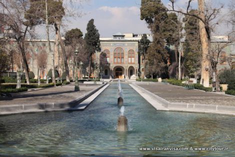
Length of these walls measured to 6000 paces. Shah Abbas appointed a chief magistrate for Tehran, and furthermore ordered the planting of a plane-tree grove, the site of which later became the Arg of Tehran (Tehran Citadel).
From this point on, Tehran joined the ranks of the Safavid dynasty cities; a city with walls comprised of 114 forts and renowned gates, namely:
1) The Shah Abdul-Azim Gate
2) The Doolab Gate
3) The Shemiran Gate
4) The Qazvin Gate
Afghans selected the city citadel as their living quarters, and as an escaping measure, they constructed a bridge over the moat of the northern side of the citadel safeguarded by a gate called Arg. With the fall of the power in to the hands of Nadir Shah (reigned 1736-1747), Afghans realized that they lacked the military strength to confront his forces and the impending danger, so they decided to ravage the city and massacre its inhabitants; that they did, and left behind numerous corps, many homeless, and a large number of ruined structures.
Agha Mohammad Khan, in 1200/1785, designated Tehran as his capital city, and after the elimination of all his rivals and enemies, he was formally crowned as Shah at the Tehran citadel. From this point on and until the fall of the Qajars, Tehran carried the title of Dar-ol Khelafeh (the seat of the Caliphate) bestowed upon it by Agha Mohammad Khan, He was succeeded by his nephew Fath Ali Shah (reigned 1797-1834). During Fath Ali's reign, Tehran gradually improved and became more developed.
New buildings were erected, the population growth began and upward trend with speculations that Tehran's population, in those years, was some where from 15 to 20 thousand.
Tehran's truly remarkable growth coincided with the reign of Naser-e-Din Shah.
The population of the city, over the course of a five year period, increased as much as three to four times. The number of people that lived in Tehran amounted to 155, 736.
Tehran at that time embodied the districts of Arg, Udlajan, Chal Maydan, Sangelaj, Bazaar and a number of outlying buildings around Tehran known as the out of city quarters.
An Important population characteristic observed in this census was the fact that immigrants constituted 73.4 percent of the population; while a mere 26.6 percent were accounted as Tehrani borns, Azarbayjanis, Isfahanis and Kashanis formed the majority of the immigrants, respectively.
During the reign of Mozaffar-e-Din Shah (reigned 1896-1907), Tehran did not undergo any drastic developmental activities, but unfortunately, over the course of his successor's reign, Mohammad Ali Shah (1907-1909) many severe damages were inflicted upon Tehran.
After the establishment of a constitutional government, Tehran has been declared, in the constitution, as the capital and the seat of the Majlis.
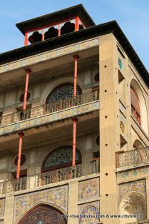
With power shift from Qajar to Pahlavi, Tehran adopted the features of a European city.
The avenues of Bozarjomehri, Molawi, etc. are among manifestation of the above period, later, however, other roads and modern buildings with the supervision of foreign engineers were constructed for the governmental and non-governmental entities.
In the year 1302/1923, the population of Tehran amounted to 210.000 and by 1318/1639 reached the figure of 540.000, and during the World War II, following the occupation of Iran by the Allied Armed forces in 1321/1941, it increased to 880.000. This upward trend was mainly due to the first two decades of the thirteenth century's (solar calendar) boom in the construction activities for the erection of government buildings and palaces.
According to the first general census the population of the city amounted to 1.512.000.
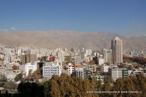
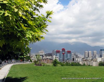
It was from this point in time that the expansion progress of the city took gigantic dimensions; small and large satellite towns as well as new districts were developed in the south, east and west of Tehran, all of which gradually became within the city limits of Tehran.
The element of heavy traffic and the need for a more speedy transportation, paved the way for the construction of major highways.
As a result, Tehran-Shemiran and Tehran-Rey travelling distances (subsequent to the demolition of brick-lines and the development of market centers, automobile service station, workshops, and residential dwellings) became an insignificant factor. At that point in time, according to the 1345/1966 census, the population of Tehran was 2.700.000, and by the following enumeration of the people living in Tehran, the number registered was 4.530.000.
 Tehran